
Lap Of Lake Ontario
1,000km Brevet, July 9 - 12, 2014
| Start Controle | Map |
| Start | http://www.gmap-pedometer.com/?r=3573577 |
| Oswego | http://www.gmap-pedometer.com/?r=3573584 |
| Cape Vincent | http://www.gmap-pedometer.com/?r=3573587 |
| US/Canada Border | http://www.gmap-pedometer.com/?r=3853301 |
| Millhaven/Bath without Ferry | http://www.gmap-pedometer.com/?r=3853382 |
| Millhaven/Bath with Ferry | http://www.gmap-pedometer.com/?r=3574150 |
| Belleville | http://www.gmap-pedometer.com/?r=3853485 |
| Brighton | http://www.gmap-pedometer.com/?r=3573398 |
| Bowmanville | http://www.gmap-pedometer.com/?r=3682227 |
| Stouffville | http://www.gmap-pedometer.com/?r=3573459 |
| Erin Mills | http://www.gmap-pedometer.com/?r=3573475 |
| Hamilton (Not a controle) | http://www.gmap-pedometer.com/?r=3853631 |
| Canada/US Border | http://www.gmap-pedometer.com/?r=3573500 |
| Olcott | http://www.gmap-pedometer.com/?r=3573505 |
| Charlotte | http://www.gmap-pedometer.com/?r=3573572 |
The LOL 1000km brevet is a RUSA sanctioned, ACP accredited brevet.
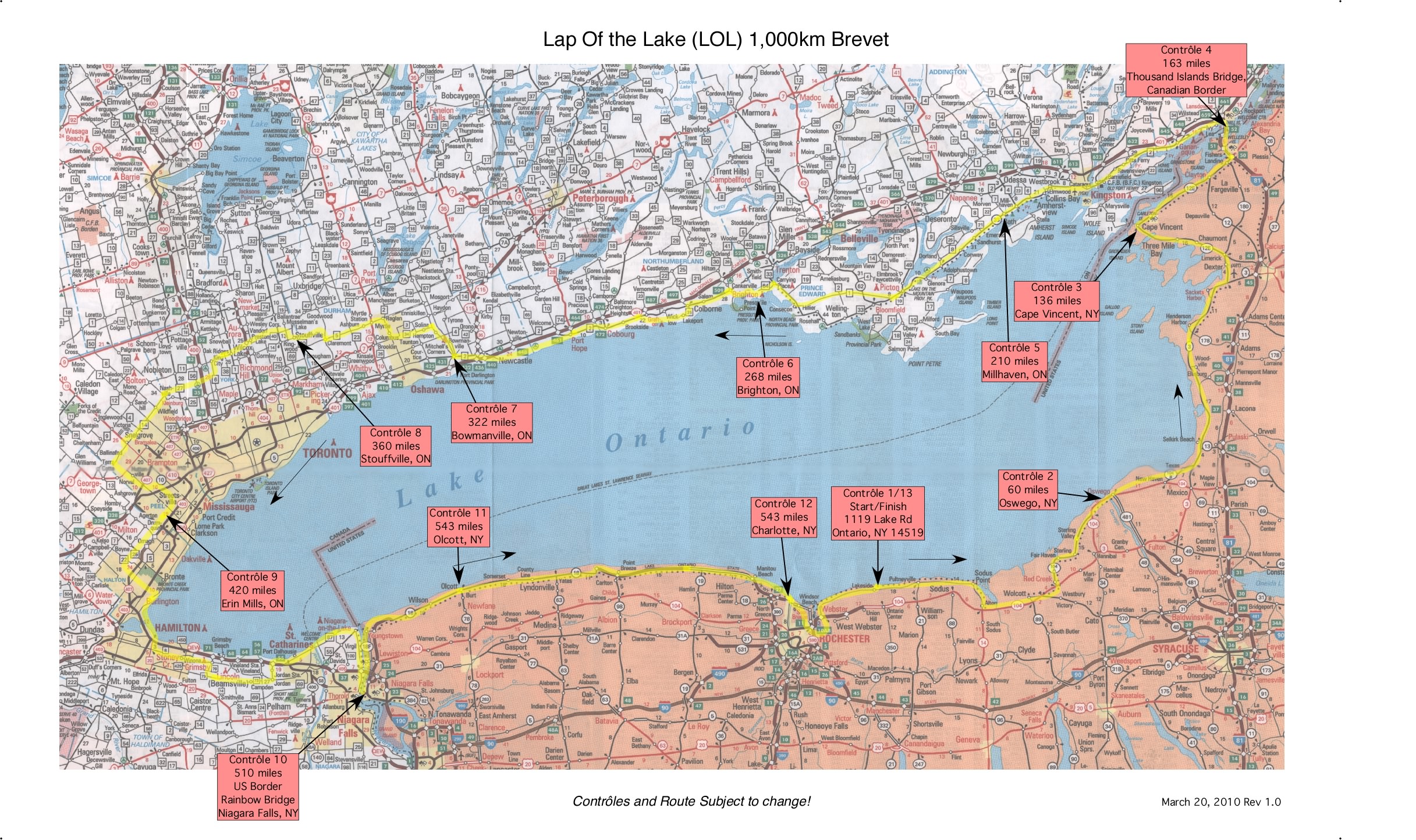
The ride starts in Ontario, NY and circles Lake Ontario in a counter clockwise direction. The route hugs the shoreline as much as practical, for best scenic enjoyment. The route is often at the waters edge and in view of the lake for much of it's distance. We pass several historic sites from the War of 1812. Cyclists from both sides of the border can pass the miles debateing who won, or lost, that campaign. In the US the ride is mostly on the Seaway Trail, a signposted, designated scenic route, with the occasional detour to avoid heavy traffic. The route goes into the Thousand Islands region before crossing into Canada on the Thousand Islands bridge, where I81 meets the Canadian border. In Canada we follow the Waterfront Trail, catching a ride across the Bay of Quint on the Glenora Ferry, down the shoreline to Newcastle, then head north around Toronto to avoid the big city congestion.
The route rejoins the lake shore just west of Mississauga, then continues around the western end of lake Ontario past Hamilton harbour to Niagara On the Lake. At this junction of river and lake, the route follows the Niagara river south on the quiet, scenic Niagara Parkway to cross the border back into the US in sight of Niagara Falls on the Rainbow Bridge in Niagara Falls. We then rejoin the Seaway trail, following the Niagara river north back to Lake Ontario. The route follows the shoreline through small picturesque villages, picking up the Lake Ontario Parkway to Rochester, around Irondequit Bay and back to the start in Ontario, NY.
The terrain is generally flat to mildly rolling.
Two Ontarios, in two countries, two border crossings, one major world city, a route that includes Mexico and Canada, a ferry ride and a scenic route past scenic wonders known around the world, what could be better for a brevet!
If you've never cycled in a foreign country, and are considering your first PBP this year, I believe you'll find this ride an excellent training experience for cycling in France, but, likely, without the language issue!
Please read the Frequently Asked Questions for more information about the route, border crossings etc.
The ride is run in the Western/Central New York RUSA region. Please contact the RBA for more information.
Last change, November 5, 2013 for the 2014 running